Instead of “Iceberg ahead, Captain”!
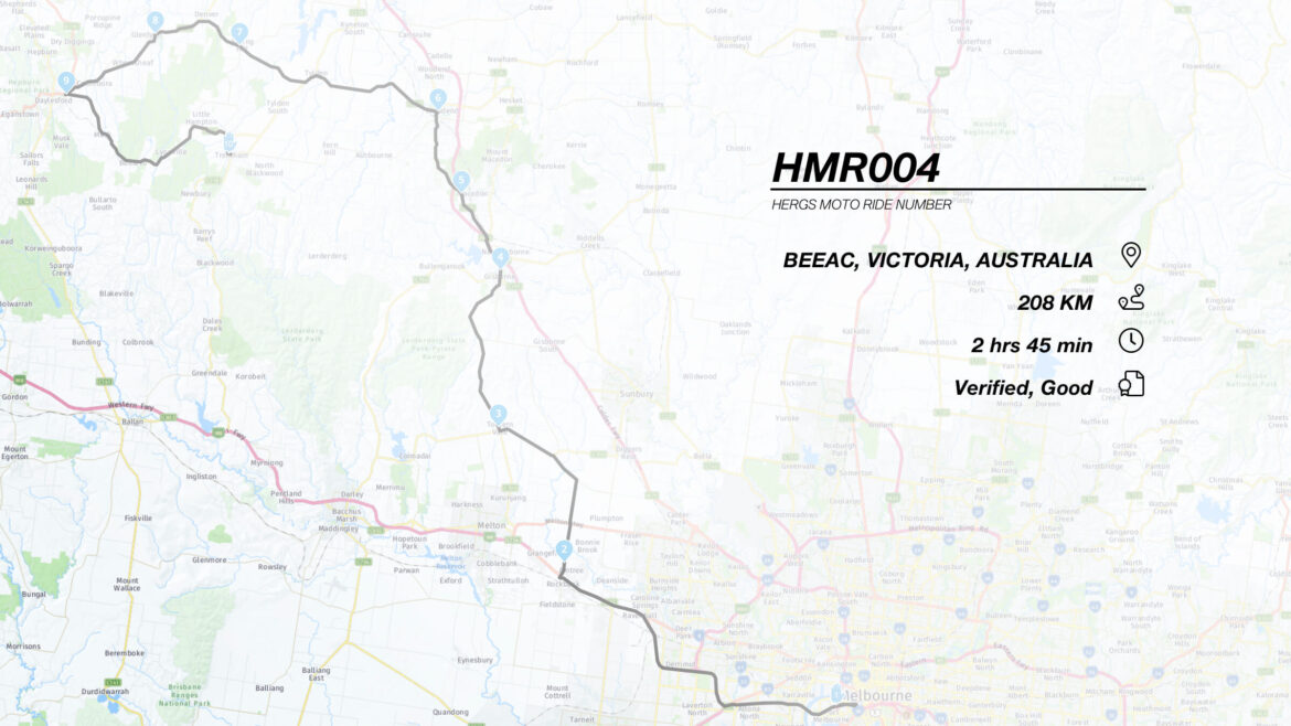
This ride to lunch from Melbourne takes you over a variety of landscapes – ranging from valleys to hills, farmland to salt lakes, ending up at a country hostelry in a small farming community. This ride is just over 200 km in length.
WHERE TO?
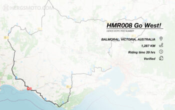
This ride takes you from Melbourne out to the South West of Victoria, to the thriving little community of Beeac.
An online version of the route map may be found here: https://www.myrouteapp.com/en/social/route/3940816?mode=share
POINTS 1 TO 2 – GETTING OUT OF TOWN
The ride starts from the United Service Station that is outbound on the Westgate Freeway. Follow the Westgate until the Western Ring Rd (M80) turn off. Take the exit onto the M80 and ride past the Mobil Service Centre. From there, take the exit onto the M8 Western Freeway. Keep on the Western Freeway for about 15 km, until you get to Rockbank and take the Leakes Rd exit to turn left onto Leakes Rd. This is standard freeway riding which is not at all interesting, but a good way to get out of town relatively quickly.
Follow Leakes Rd to its T-junction with Greigs Rd and turn right. At this location, you will see a collection of buildings, which once comprised the first radio receiving station for international radio communications in Australia. We travel past its transmitting radio station counterpart in Fiskville later on in the ride.
From here on, travel west along Greigs Road following the dog leg onto Mt. Cotrell Road and back onto Greigs Road again. Point 2 is at the site of Melton Reservoir.
POINTS 3 TO 6 – OVER HILL AND DALE TO BUNINYONG
Keep on this road, which becomes Exford Rd and then Nerowie Rd through the farmland and grassland, until you come to the intersection of it and the Bacchus Marsh-Geelong Rd. Cross over the intersection onto Glenmore Rd, which runs alongside the Bacchus March airfield. The view ahead is of the hills of the Brisbane Ranges, and you will often see gliders from the airfield taking advantage of the wave lift generated by the hills.
Stay on Glenmore Road and cross the roundabout at the intersection of Balliang Road. From here, you enter the Yaloak Valley and the fun really begins as the this video clip shows.
The road twists through the valley – which is quite scenic and does remind one of riding through a remote Scottish or Welsh valley. The road surface is variable in quality, so do keep an eye out for large potholes and lumpy bits of hot mix. After about 9 km, you get to the hamlet of Glenmore, where the Lady Northcote Camp is located. The road narrows here, so it does pay to take it easy through here.
There are a few crests through here and I have vivid memories of zooming over one of the crests, to be greeted by the bucolic sight of a Wedge Tailed Eagle – a very LARGE Wedgie – having its dinner in the middle of the road. I hit the brakes and the Wedgie hit the wings but being a large, ponderous bird, it took quite a long while to reach flying speed. Luckily, my deceleration and its acceleration coordinated to create a near miss!
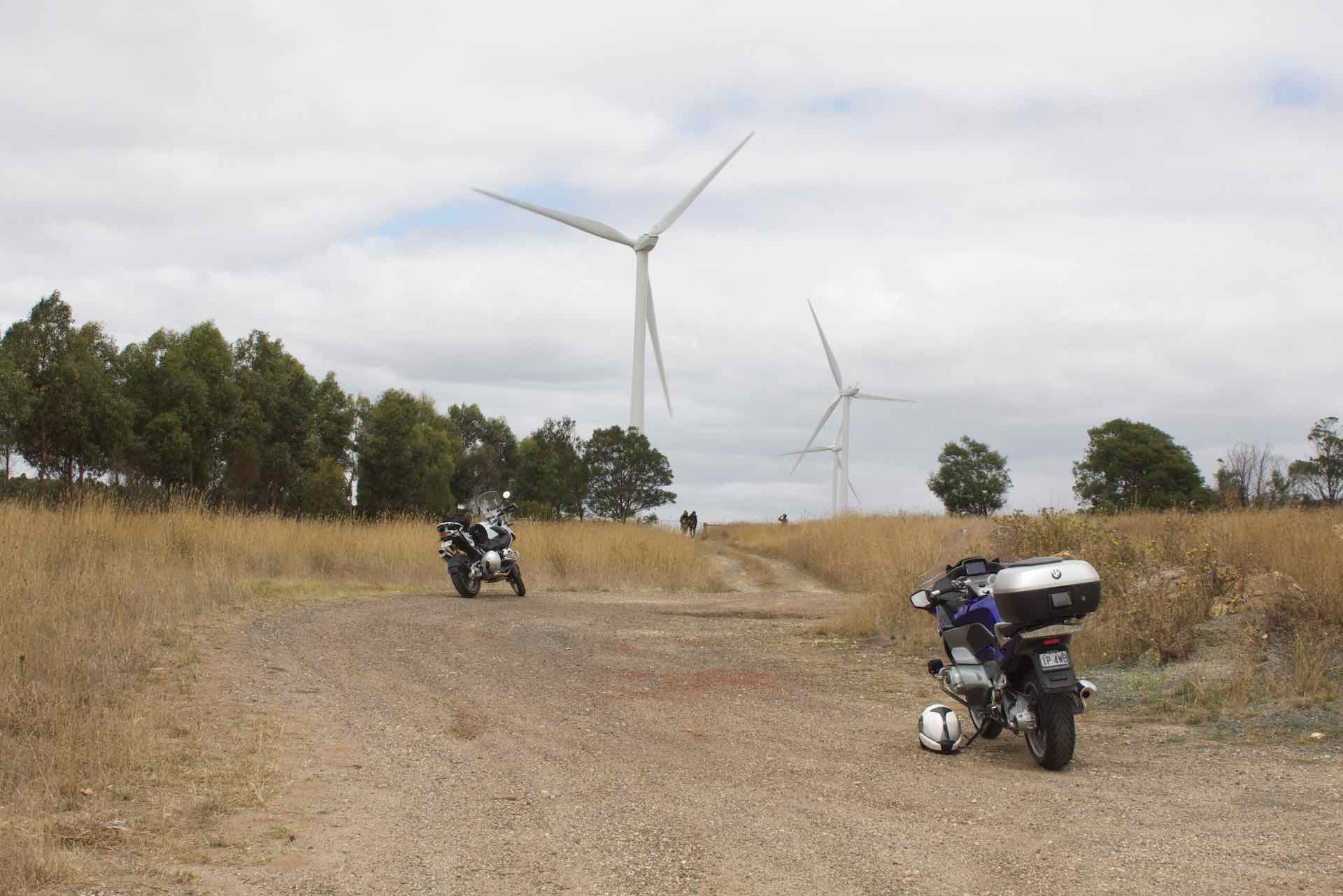
You are soon presented with the end of the Yaloak Valley with a steep winding climb on a badly sealed and narrow road. Be careful through here, as oncoming vehicles can quite easily come over to your side of the road due to a combination of bad road surfaces, driver inattention and a spectacular view over the valley.
At the top of the climb, you are greeted by a farm of wind turbines [see the first picture in this ride story] – and the aforementioned spectacular view of the Valley.
After a quick break, continue along the now very bumpy road to the Geelong-Ballan Road, where you turn right.
After about 5 km, you will see the old CFA Fiskville Training Centre on your left. This was the twin radio station to the one at Rockbank. Just before Ballan, you will see the turn off to Mount Egerton, so take the left turn here and head to Mount Egerton.
This road is another great one. Through the forests and into the valleys onto Mount Egerton, which is now a small village and still has a gold battery located within it. Turn left at Mt. Egerton and head to Yendon. There are quite a few wind turbines located on this road. Keep following it until you get to the T-junction with the Midland Highway just after Mount Buninyong. You ride into Buninyong shortly after this, and it is a good place to fuel up and get a coffee.
Two places that may be recommended are:
The Espresso Depot and The Buninyong Bakehouse Cafe.
There are several other eateries on offer as well, all of which look to be rather suitable!
POINTS 7 TO 10 – THROUGH THE FOREST TO CAPE CLEAR
After being suitably refreshed, head west on the Midland Hwy towards Ballarat. Take the left turn onto Scotchman’s Lead Road, which connects with the Colac-Ballarat Road at Napoleons. Turn left and head south through the forest and farmland, through Enfield (where the Little Hard Hills Hotel is located) onto Dereel. This is point 8. Turn right just before the township onto the Rosewood-Dereel Road. This winds its way through the hills and is rather scenic and has sweepers to keep you entertained.
At the end of the road, you have arrived in the vicinity of Rosewood Junction. A right turn here onto Cape Clear-Rokewood Road provides an entertaining ride through to the thriving metropolis(?) that is Cape Clear.
At Cape Clear, there are two main items of note: Firstly, the Cape Clear Hotel, which was sadly closed the last time I visited. Up until a couple of years ago, it served delicious meals and was a most pleasant place to spend an afternoon. Secondly, there is this:
Yes! …a light house in the middle of country Victoria!
Why? Well, apparently the town was named Cape Clear by the Irish workers who migrated to the area, so a model lighthouse was built to commemorate the lighthouse in their home town.
POINTS 11 TO 13 – ONWARDS TO LUNCH.
Turning left at the T-junction here onto the Pitfield-Scarsdale Road, head south and merge onto the Pitfield-Cressy Road, which meanders over gentle hills and dales onto the Hamilton Hwy just outside of Cressy. A left turn here will get you onto the Cressy turn off in short order. Turn left into Cressy and continue south onto the Colac-Ballarat Road.
This road is generally in good condition and fairly flat. It is about 20km to Beeac, which is the end of the ride.
At Beeac, the Farmers Arms Hotel is an excellent choice for lunch, The food is of high quality, reasonably priced and the service is both friendly and efficient. Thoroughly recommended!
There is also a small cafe/take away in town, along with an ice cream shop. There is also a private car collection there, which may be open for display if you are lucky. Across the road from the pub there is an interactive history of the town, which I found very interesting. It is sometimes hard to imagine how busy these towns were a 100 years ago and that a railway line and station ran through the town to Cressy.
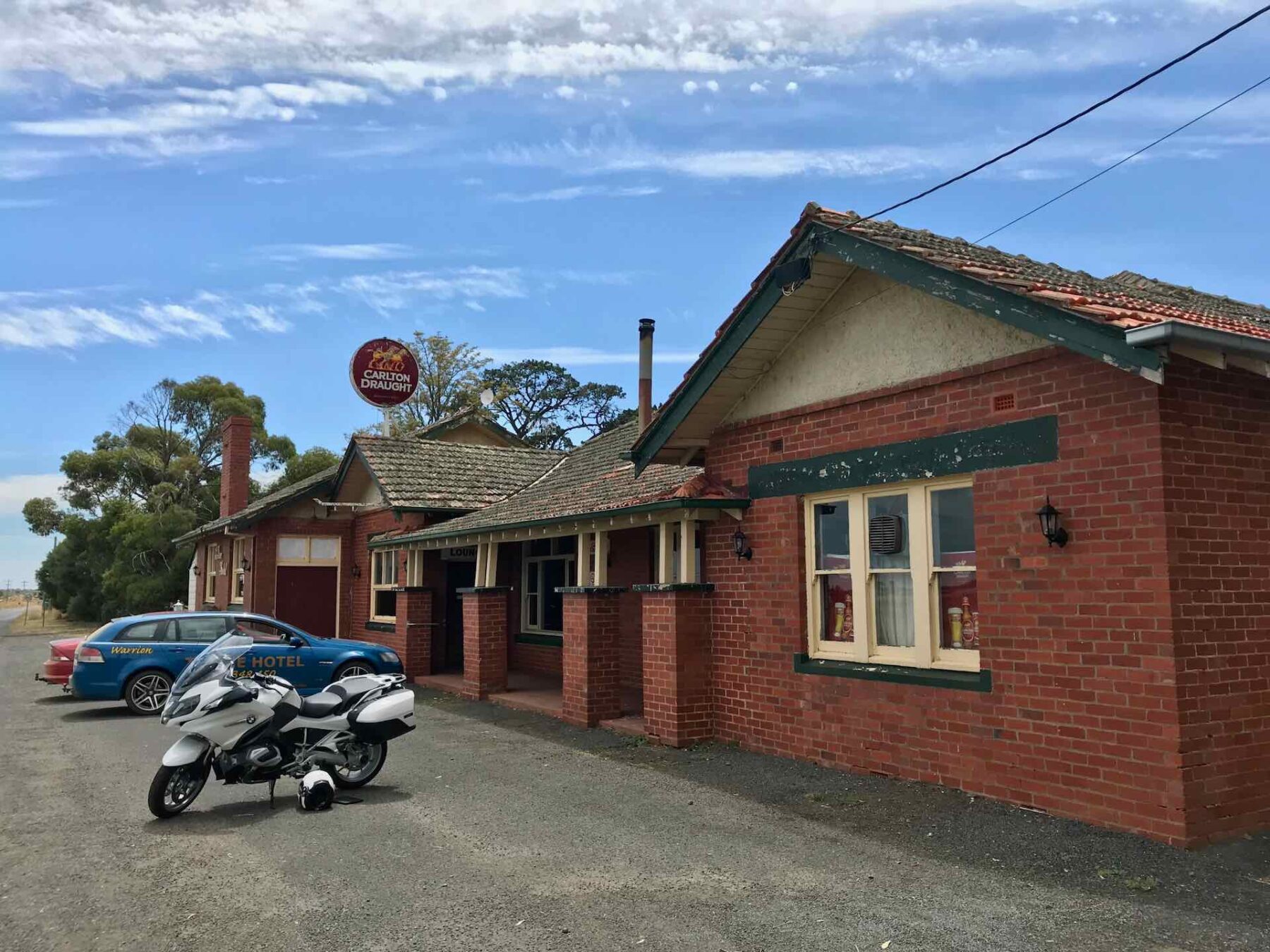
Another good country pub which is nearby is the Ti-Tree Hotel, which is located in nearby Warrion on the Coragulac-Beeac Road.
From either Warrion or Beaac, it is a short ride to Colac, where fuelling up may be a good idea.
I find this to be a somewhat relaxing, laid back ride. I plan to do it and head to the pubs mentioned above as soon as Melbourne’s Covid19 lockdown is over!